Bahá'í Library Online
. . . .
.
>>   Maps
TAGS: Maps; Ten Year Crusade
> add tags
Abstract:
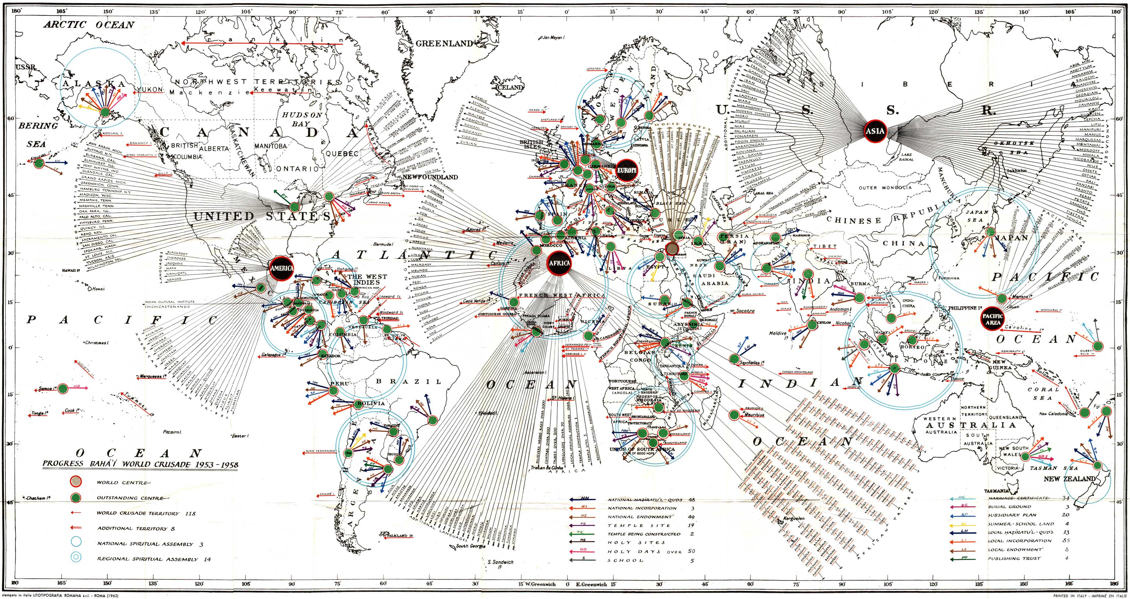
Statistical information such as LSA incorporation, temple construction, etc.
Notes:
Published as a pull-out in The Bahá'í Faith 1844-1963: Information Statistical and Comparative. Also published in Bahá'í World Volume XIII: 1954-1963.

See also Index to Maps and charts in Bahá'í World volumes.

The creases in the image existed in the original poster I used; I scanned the large original in ten separate scans and then collated them to produce this electronic image. [-J.W.]


Progress Bahá'í World Crusade 1953-1958

by Shoghi Effendi

published in The Bahá'í Faith 1844-1963: Information Statistical and Comparative
Haifa: Bahá'í World Centre, 1963
Italy: date of original: 1962
(Original map measures 53 cm high x 98 cm wide.)


small JPG (1 MB)

large PNG (18 MB)
About this map (material collected by J.W. Conkling):

Although there is no identification on this map as to its originator we know from references to it by the Hand of the Cause of God Ugo Giachery that it was prepared by Shoghi Effendi. He gave the original to Mr. Giachery to have printed in Italy. Mr. Giachery writes about the printing of this map and an earlier map published in 1953 denoting the goals of the Ten Year World Crusade in his book Shoghi Effendi: Recollections (George Ronald, pp. 43-46) as follows:
“Twice it was my good fortune to handle the reproduction of two maps which Shoghi Effendi made to show to the Bahá’í world the goals and progress of the Ten Year Crusade: the ten year international Bahá’í teaching and consolidation plan, 1953-1963, and the victories won during the first five years of this plan, 1953-1958. [See the other map at bahai-library.com/shoghieffendi_goals_crusade.] The original maps entrusted to me for reproduction were drawn by Shoghi Effendi’s own hand. They represented the entire world, including the Arctic and Antarctic regions. By the ingenious and artistic use of well-conceived lines, colours, circles and other symbols, Shoghi Effendi presented on these maps (each on thirty-eight inches by twenty-two inches) the whole content of hundreds of pages of printing.

“The first original was brought to me in Italy by a pilgrim returning from the Holy Land in the latter part of 1952. It had to be reproduced in time to be annexed to the booklet The Bahá’í Faith 1844-1942: Information Statistical and Comparative, to be published simultaneously in London and in Wilmette [IL]. It was also intended for the Intercontinental Teaching Conferences held in Kampala, Chicago, Stockholm and New Delhi in 1953, and for the twelve National Bahá’í Conventions held in April of that same year. Knowing the reluctance of the Italians in general to print anything of which the Church of Rome may disapprove, I had to move wisely and cautiously to find a printer in Italy who would undertake to carry out the project without fear or eventual regret. After some unsuccessful attempts, when I was turned down for incredible reasons, I was able to locate a firm which agreed to execute the work. Map printing is an art in itself. It requires special machinery which at that time was not readily available in a country that was slowly recovering from the ravages of a disastrous war. . . .”

“As soon as the first copies of the first map came off the press, a sample was sent to Shoghi Effendi. It was swiftly acknowledged with a cable of thanks and praise. Instructions for a second printing were received in the spring of 1953, thus necessitating my presence in Italy and preventing my taking part in the Intercontinental Conference held in the United States.”

“The second map was prepared by Shoghi Effendi during the summer months of 1957.... He had been so pleased at the development of the first four and a half years of the Ten Year Crusade that, in his message of October 1957 (which was to be his very last), he called for the holding of five Intercontinental Conferences in 1958. At this time the second map, depicting the victories with true originality and accuracy, was to be presented.

”When, on 4 November 1957, the light of the world was dimmed by his passing, and I rushed to London at the request of Rúhíyyih Khánum, the map had just been finished. On entering his room, the day after his passing, I saw it lying on two small mahogany tables that had been drawn together to make the necessary wide space available. Coloured pencils, pens, penknife, eraser, rulers and a compass were lying to the right of the map, just as he had left them when, in the late afternoon of the previous day, turning to Ruhiyyih Khanum, he had said: ‘The map is now finished’.

“The next morning he winged his flight to the Kingdom on High, but the map was there, to testify to his love for mankind and to what he had created to bring about its unity.”
from Shoghi Effendi: Recollections
Back to:   Maps
Home Site Map Links Copyright About Contact
.
. .